Changing our landscape
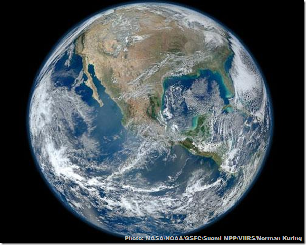
In the pristine zero-gravity wilderness of outer space, Earth shines like a beacon. Reflecting sunlight off silvery white clouds, opal blue oceans, and forest-tinged brown of continents, it’s hard to imagine from this image that humanity is making any kind of imprint on our world.
But we are making more than an imprint; we are stamping our metal feet into the Earth and spewing carbon by the ton into the atmosphere. In turn, we are leaving the Earth in much worse shape than we found it.
Haze has settled over cities. Once green, fertile areas have become desert. Metal encroachments creep into the soil. All the while, NASA has photographed the progress from space. Here are seven jarring images of human impacts on Earth, as seen from space. (Text: Katherine Butler)
1. Dynamic changes in the Yellow River Delta
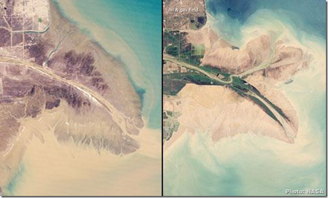
China’s Yellow River along the Gulf of Bohai is known to be the most sediment-filled river on Earth. Also called Huang He, the Yellow River flows 5,475 kilometres (3,395 miles) from eastern Tibet to the Bohai Sea. During this journey, it crosses a wide plateau filled with fine soil, which deposits into the eco-sensitive delta at the mouth of this river. This has historically allowed the river to reshape the coast.
However, in 1996 Chinese engineers blocked and redirected the river northward. This has caused a level of erosion that has extensively reshaped the delta.
Here we see the delta imaged by NASA’s Landsat satellites in 1989 (left) and 2009. The 2009 image reveals that the shoreline has been reshaped to protect a series of coastal oil and gas wells. As odd at is seems, this “may be the outcome that the engineers were anxious to achieve.”
2. Epic deforestation
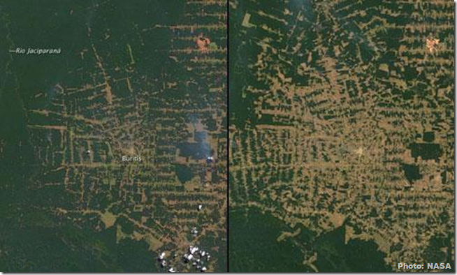
In the past 40 years, as much as 20 percent of the Amazon rain forest has been cut down. The rain forest produces half of its own precipitation. As the forest is destroyed and burned for industrial purposes, the remaining trees dry out and die. This activity has made Brazil one of the largest greenhouse gas emitters on the planet.
Pictured here is the state of Rondônia in western Brazil as imaged by NASA’s Terra satellite. This 51.4 million acres of forest was once roughly the size of Kansas [USA], according to NASA, but now it is on track to becoming the most deforested part of the Amazon.
How bad is it? NASA reports that 4,200 square kilometres [of land had been] cleared by 1978; 30,000 by 1988; and 53,300 by 1998. By 2003, an estimated 67,764 square kilometres of rain forest - an area larger than the state of West Virginia [USA] - had been cleared. Here we see the area in 2000 (left) and 2010.
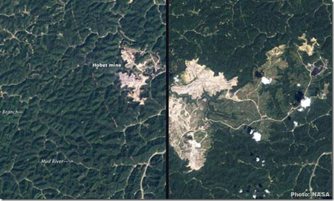
3. Mountaintop removal mining in West Virginia
As the name implies, mountaintop removal mining involves the highly profitable removal of a mountaintop via explosives by coal mining companies. Companies then mine coal seams previously trapped beneath the rock.
While coal companies attempt to rebuild the mountaintop in an approximation of its original appearance, excess rock and dirt containing toxic mining products are dumped into area valleys and streams. As NASA reports, the environmental and health effects of this kind of mining on area soil and water are called “pervasive and irreversible” by experts.
Pictured here is the Hobet surface mine in Boone County, West Virginia [USA], as imaged by NASA. We see the area in 1984 (left) and 2010. In 1984, the mine was still relatively small. By 2010, it had completely filled the Connelly Branch to the Mud River.
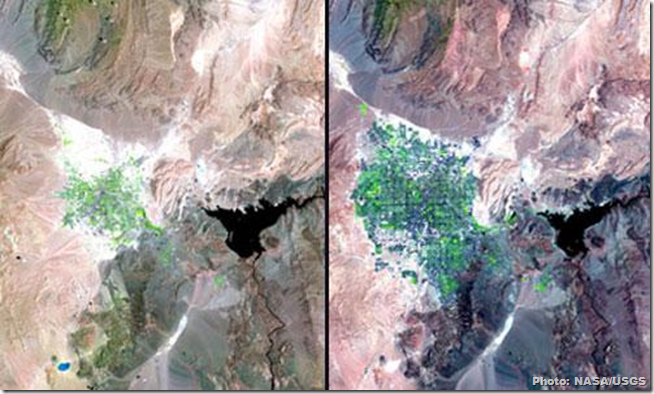
4. Las Vegas: Growth in the desert
Lake Mead is a huge reservoir of the Colorado River and responsible for providing water to Nevada, Arizona, California and northern Mexico. A recent severe 11-year drought caused the lake to drop to levels not seen since 1956. Then there’s the taxing draw of Las Vegas, its closet city.
Pictured (left) is Las Vegas in 1984 as imaged by NASA’s Landsat-5 satellite. On the right is the city in 2007. These photos depict the growing urban sprawl of Las Vegas. Nearby is the shrinking Lake Mead, which is located on the border of Nevada and Arizona.
The drain on Lake Mead is due to the rapid growth in Las Vegas, as well as below-average rainfall. Lake Mead provides as much as 90 percent of southern Nevada's water. Fortunately, a wet winter allowed the lake to recover a bit in 2011.
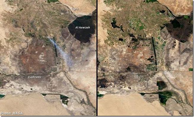
5. The marshes of Iraq
The marshes of Iraq have a rich environmental and cultural history. For thousands of years, these Mesopotamian wetlands have supported a unique balance of people living in harmony with their environment. Marsh Arabs have fished the area for centuries while living in huts woven from reeds. But in the 1990s, Saddam Hussein drained the marshes to prevent supposed guerrilla fighters from using these resources. After his fall in 2003, Iraqis have worked to restore the once-lush wetlands by demolishing the dams, dikes and canals set up by Hussein. Their work is being hampered by another menace - drought.
Here we see the marshes as imaged by NASA’s Terra satellite. On the left is an image from 2000. Instead of lush greenery, “the area was reduced to a few small green patches and bare soil, varying in shades from purplish brown to pale beige,” according to NASA. Any green areas are likely irrigated crops. On the right is the area in 2010 - from which it is clear the area has not recovered, and crippling drought in 2009 did not help. As Sheik Ali Hool told the Los Angeles Times, “What was once described as the Garden of Eden, the cradle of civilization, has been changed to desert and to a cradle of disease, poverty and suffering.” But there's hope: by 2010, the irrigated green areas in the centre of the image appeared to be on the path towards restoration.
6. City expansion in Kampala
Kampala is the capital of Uganda and also its largest city. Originally made up of hills and wetlands, it was considered an ideal place for hunting. Since the 1960s, the population has grown at an average rate of 5.6 percent a year. As a result, much of the surrounding forests have been lost to the need for charcoal, and area water quality has decreased significantly.
Here, you can see the city in 1974 (left) and 2008. Today, as many as 2.5 million people live in the city - and only 10 percent of those people are thought to have access to the city’s sewer lines.
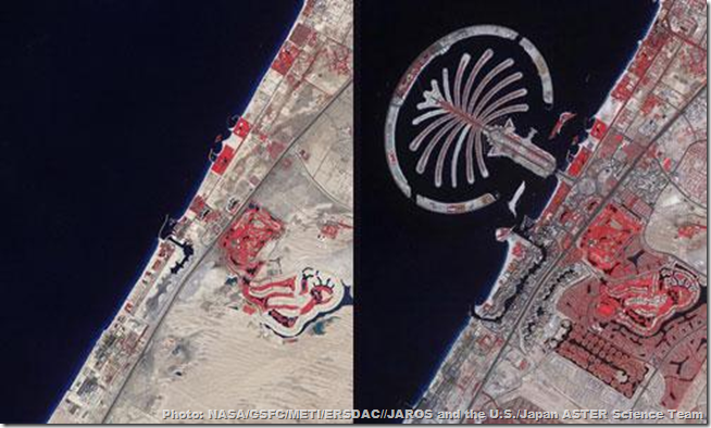
7. Dubai rises from the desert
Dubai, part of the United Arab Emirates, exists on land where rainfall is sparse. In fact, less than 1 percent of the country’s land is arable.
The city itself has been around for centuries, but at the turn of the 21st century, Dubai rose up from the sands as a resort destination with a population of more than 2 million.
Replete with gardens and golf courses, palm trees now line the coast. This is possible due to oceanic desalinization plants that have enabled the city to water itself. In this false-colour image, “bare ground appears brown, vegetation appears red, water appears dark blue, and buildings and paved surfaces appear light blue or grey.”
The famous palm-shaped island is part of an effort by Dubai to increase the amount of beachfront around the Persian Gulf. Palm Jumeirah is one of several islands created by dredging up sand from the seafloor.

No comments:
Post a Comment
Please adhere to proper blog etiquette when posting your comments. This blog owner will exercise his absolution discretion in allowing or rejecting any comments that are deemed seditious, defamatory, libelous, racist, vulgar, insulting, and other remarks that exhibit similar characteristics. If you insist on using anonymous comments, please write your name or other IDs at the end of your message.