Balancing boulders that teeter precariously on spires of rock, rolling waves of sandstone with perfectly colored stripes (like The Wave in Arizona, top image), weathered mountains carved into animal shapes. These are all examples of amazing rock formations that look like they were created by human hands. But they weren't. They're all completely natural, most are ancient and visitors flock to them each year armed with cameras and a tremendous sense of awe.
Here are 13 rock formations created by Mother Nature that may be worth a visit - even if that visit is just a digital one.
1. Wave Rock
This well-known landmark in Western Australia was formed 2,700 million years ago, according to the Australian government. At nearly 46 feet tall and 360 feet long, this granite cliff looks like a huge ocean wave about to break.
Wave Rock forms the north side of Hyden Rock, which is a granite inselberg - an isolated rock hill or small mountain that rises abruptly from a flat plain surrounding it - with three domes. The curved face of the cliff has been rounded out over the years through water erosion from two main sources. First, when it rains, inselbergs shed rain water, and the surrounding plains receive the runoff. This causes weathering on the rocks on the sides of the hill and is part of the reason for the concave slope of Wave Rock. Second, as the face of the granite cliff has eroded over the years, groundwater has risen to the surface. That groundwater continuously dissolves and re-deposits chemicals in the granite as it runs down the cliff, resulting in the striped pattern we see today.
2. Eye of the Sahara
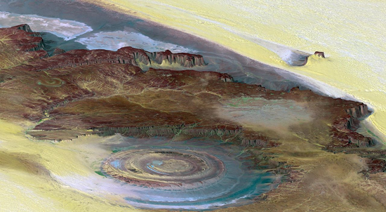
The Eye of the Sahara, also known as the Richat Structure, forms a bulls-eye of sorts in the middle of an otherwise featureless desert area near Quadane, Mauritania. The structure is about 30 miles in diameter, according to NASA - it's so big and colorful that astronauts use it as a landmark from space.
Its circular shape originally led experts to believe it formed from a meter impact, but NASA says "it is now thought to be merely a symmetrical uplift that has been laid bare by erosion." Today, the "uplift" stands about 650 feet high - nearly 1,600 feet above sea level.
Why is it blue? Kediet ej Jill Mountain, Mauritania's highest peak (3,280 feet tall), is nearby, and the mountain has a large concentration of magnetite, giving it a blueish tinge.
3. Thor's Hammer
Hoodoos are tall, skinny rock spires that rise up from arid basins, such as the High Plateaus region of the Colorado Plateau and in the Badlands regions of the Northern Great Plains, according to the National Parks Service (NPS). But it's Bryce Canyon National Park in southwestern Utah that has more hoodoos than any other place in the world.
The unusual rock formations are often described as having a "totem pole-shaped body" and can be as tall as a person or a 10-story building, like Thor's Hammer (seen toward the left of the above photo). The hoodoos in Bryce Canyon National Park formed about 40 to 60 million years ago. The NPS explains how they came to be: "The primary weathering force at Bryce Canyon is frost wedging. Here we experience over 200 freeze/thaw cycles each year. In the winter, melting snow, in the form of water, seeps into the cracks and freezes at night. When water freezes it expands by almost 10 percent, bit by bit prying open cracks, making them ever wider in the same way a pothole forms in a paved road."
Rain plays a big role in sculpting hoodoos, too. Hoodoos have layers of several different kinds of rock - one of them being limestone. The slightly acidic rainwater slowly dissolves the limestone, resulting in the rounded edges and lumpy silhouettes.
4. Queen's Head
Queen's Head in northern Yehliu, Taiwan, is part of a group of mushroom rocks, which have globe-shaped rocks on the top supported by thin pillars on the bottom. Queen's Head is the most famous of the mushroom rocks, attracting 3 million visitors a year, according to the AFP news agency.
Mushroom rocks inherit their shape thanks to a few different environmental factors. First, notice that the rock has more texture on top than on the bottom. This is because of sand erosion, according to the University of Wisconsin. Wind-blown sand helped carve the mushroom rock, but wind can only lift sand a few feet in the air, so the upper portion of the rock is more textured since it hasn't been as shaped by this force. Second, the top of the rock may contain more calcium than lower portions, making it more durable against erosion.
That said, this queen is in danger: The 4,000-year-old sandstone structure is eroding quickly and may soon disappear. Her head is getting too heavy as her neck shrinks by about 1.5 centimeters a year, scientists say, and the 26-foot-tall rock may only have about 10 years left.
5. Rock Sites of Cappadocia
Göreme National Park and the Rock Sites of Cappadocia in Turkey have been listed as a World Heritage Site since 1985. Natural forces shaped this rocky landscape, but then humans took the reins from Mother Nature and created a very cool locale. But let's back up for a second and explain how it formed in the first place.
Ancient volcanoes erupted and blanketed the area with thick ash, which solidified into a plateau. (This national park is bordered on two sides by extinct volcano ranges.) Over the years, wind and water have eroded it, "leaving only its harder elements behind to form a fairy tale landscape of cones, pillars, pinnacles, mushrooms, and chimneys, which stretch as far as 130 feet (40 meters) into the sky," National Geographic reports.
Often called "fairy chimneys," these rock structures are another example of hoodoos. Around the 4th century, humans began carving cave dwellings, places of worship and even entire underground towns into the rocks - some reported to be as many as eight stories deep. While they were originally occupied by monks and Christians fleeing Rome's persecution, today they serve as museums that preserve examples of Byzantine art and hotels that offer a unique experience for tourists.
6. Skull Rock
Skull Rock in California is a favorite stop for tourists in Joshua Tree National Park. This rock started forming long ago as depressions in the granite filled with rainwater, leading to erosion. As time passed, the two eyes formed and it started resembling a skull, the National Parks Service says.
These days, the skull is the starting point for a 1.7-mile nature trail through the park, where the Mojave and the Colorado deserts meet in southern California.
7. Pamukkale
Pamukkale is one of Turkey's top attractions, and it's easy to see why. With its expansive bleached terraces and brilliant blue pools, Pamukkale, which means "cotton castle" in Turkish, looks just like its name suggests.
The travertine basins are filled with thermal spring water and get their white color from calcite deposited by the water as it pours over the edges of the pools. That calcite-laden water also creates petrified waterfalls that look frozen in time.
Locals and tourists alike have bathed in these pools for thousands of years. These days, however, protections are in place to safeguard this gorgeous historical site. Visitors cannot wear shoes, for example, to protect the mineral deposits. And many hotels that had been built nearby were demolished when it became a World Heritage Site since 1988, because the hotels were damaging the terraces.
8. Devils Postpile National Monument
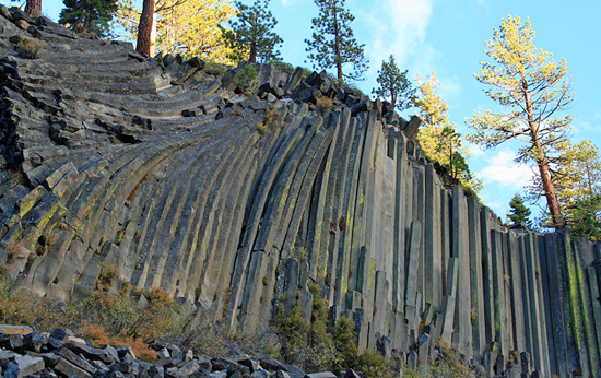
The Devils Postpile in California may be one of the younger rock formations on this list, as recent studies show it was formed less than 100,000 years ago when a lava flow cooled and cracked into multi-sided columns. This particular type of lava - basaltic lava - is rich in iron and magnesium and is normally much hotter than other types of lava, according to the National Parks Service. Because of this, basaltic lava flows more quickly, and that's exactly what it did tens of thousands of years ago as it flooded Reds Meadow Valley until it was blocked by a natural dam, creating a lava lake about 400 feet deep.
The lava cooled at different rates, with shallow parts of the lake hardening first. As it cooled, the solid lava contracted away from the liquid lava, causing cracks or joints. These joints formed columns that now stand about 60 feet high but used to be much taller. Today, this national monument stands as a stunning example of a basalt column landscape.
9. Sphinx of Balochistan
While Egypt is home to the Great Sphinx of Giza, Pakistan's Hingol National Park is home to another sphinx that resembles its man-made cousin but was formed without the help of human hands. This sphinx, carved by wind and rain, sits atop a mountain about 155 miles from Karachi on the Makran Coastal Highway.
The Makran Coastal Highway offers visitors a peek of other unique rock formations as well, such as the Princess of Hope, a rock shaped like a human standing tall above a pile of rocks.
10. Moeraki Boulders
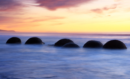
The Moeraki Boulders are a series of more than 50 spherical stones that dot a stretch of Koekohe Beach on the New Zealand coast. Each one weighs several tons and some stand more than six feet high. According to NewZealand.com, Maori legend says the boulders are "gourds washed ashore from the great voyaging canoe Araiteuru when it was wrecked upon landfall in New Zealand hundreds of years ago."
Legend aside, the rocks originally formed around 60 million years ago from sediments on the sea floor. Over time, the concretions have been exposed through shoreline erosion from waves and coastal cliffs that back the beach.
Feel free to walk on the boulders and enjoy them, but know that the Moeraki Boulders have legal protection and it's illegal to move, vandalize or damage them.
11. Heart Rock
Everything about Heart Rock is romantic. Yes, it's shaped like a heart, but it also lies in a place called the Valley of Enchantment, which sounds like something out of a Disney movie. A pool of water fills the natural formation, and there's even a 20-foot waterfall (Seeley Creek Falls) that often flows right through the heart, according to the city of Crestline, California, which calls Heart Rock a "natural wonder."
The hike to get to Heart Rock is a fairly easy one down a trail through a forest - about a mile round-trip. At the bottom of the trail is a large pool (not the pool in the heart) where people swim in the summer.
12. Chiricahua National Monument
The National Parks Service calls Chiricahua National Monument in Arizona a "wonderland of rocks." It's an apt description - the national monument was created in 1924 to protect an extensive number of hoodoos and balancing rocks, like the one pictured here. Some of these rocks rise hundreds of feet into the air and look ready to topple at any time.
About 27 million years ago, a huge volcanic eruption shook this area of southeastern Arizona, depositing a few thousand feet of dark ash and pumice, which eventually eroded into the natural features we see at the monument today.
In 2008, the national monument was added to the National Register of Historic Places. However, not many people visit as this section of the Chiricahua Mountains is difficult to access.
13. The Wave
Not to be confused with Wave Rock, The Wave is a gorgeous, rolling sandstone rock formation in the Vermilion Cliffs National Monument in northern Arizona. With its bands of red, pink, yellow and white, it's a popular destination for photographers, but due to its popularity and sensitivity to foot traffic, the state issues only 10 permits a day for visitors.
Two major troughs form The Wave: the first is 62 feet wide and 118 feet long, and the second is 7 feet wide and 52 feet long. Those two troughs were first formed through water erosion from run-off from a nearby drainage basin. But as that basin shrank, water flow stopped, though wind erosion continues.


No comments:
Post a Comment
Please adhere to proper blog etiquette when posting your comments. This blog owner will exercise his absolution discretion in allowing or rejecting any comments that are deemed seditious, defamatory, libelous, racist, vulgar, insulting, and other remarks that exhibit similar characteristics. If you insist on using anonymous comments, please write your name or other IDs at the end of your message.