

My earlier post showed a video display of the wondrous Hawaiian clouds. Clouds themselves in fact display various rare and weird formations in our sky. Accompanied by cool, stunning pictures and videos (for some clouds), the following article explains 10 of the most rarest cloud formations.
Clouds fill the skies above us and are part of our every day lives but often go unnoticed. However, there are some clouds that are so rare that you will be very lucky to see them in your lifetime. Furthermore, not many scientists study these rare, weird clouds, because their very rarity makes them relatively unimportant for studying precipitation or climate. So, oftentimes, their formation is poorly understood.
This is a list of the top 10 most rarest, strangest, yet most beautiful, cloud formations (in no particular order) that for those lucky enough to see them, were caught on camera. For most cloud types, the physics behind their formations are also explained. For those of you who are more interested in clouds, the book Cloud Book: How to Understand the Skies is highly recommended.
1. Nacreous Clouds
These rare clouds, sometimes called mother-of-pearl clouds, are 15 - 25km (9 -16 miles) high in the stratosphere and well above tropospheric clouds.

They have iridescent colours but are higher and much rarer than ordinary iridescent clouds. They are seen mostly but not exclusively in polar regions and in winter at high latitudes, Scandinavia, Alaska, Northern Canada. Lower level iridescent clouds can be seen anywhere.


Nacreous clouds shine brightly in high altitude sunlight up to two hours after ground level sunset or before dawn. Their unbelievably bright iridescent colours and slow movement relative to any lower clouds make them an unmistakable and unforgettable sight.


Here are some cool videos of these clouds, otherwise own as 'SunDog'.
Source: YouTube
2. Mammatus Clouds
Mammatus Clouds are pouch-like cloud structures and a rare example of clouds in sinking air.
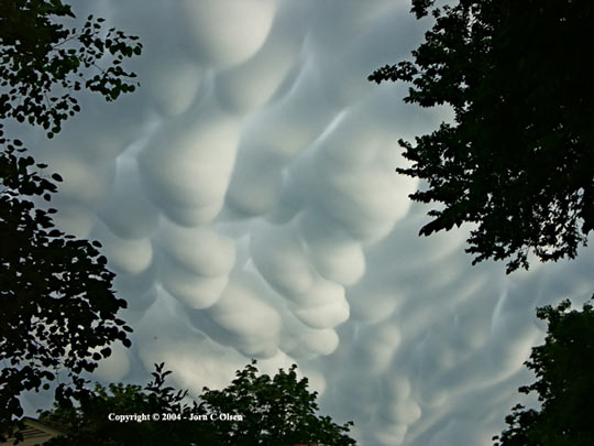
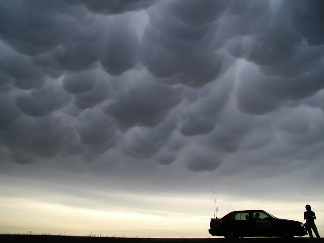
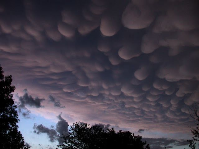
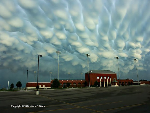
Sometimes very ominous in appearance, mammatus clouds are harmless and do not mean that a tornado is about to form - a commonly held misconception. In fact, mammatus are usually seen after the worst of a thunderstorm has passed.


Scientists do have some theories about mammutus clouds to explain the physics behind them. Buoyancy and convection of air is the key; the clouds are kind of like upside-down convection. Convection is like a buoyant bubble. In mammutus clouds, evaporation causes pockets of negative buoyancy as it cools the air inside the cloud. This makes the clouds puff downward instead of up like cumulus clouds, and they end up being like upside-down bubbles.
The reason they are smooth is the thermal structure right below them. The speed at which the temperature drops with increased height, known as the “lapse rate,” needs to be close to neutral. In other words, if you put a warm little bubble of air in a particular spot, it won’t go up or down much at all - no heat goes in or out. This is typical of the thermal structure of thunderstorms. Without these circumstances, you would get more common ragged-looking clouds or cloudy wisps coming out. The clouds need to have atmospheric conditions with some buoyancy to it in order for the formation to happen.
3. Jellyfish Clouds
Jellyfish clouds (Altocumulus Castelanus) are so called by that name because of their jellyfish-like appearance.

These formed around 17,000 ft due to when the rush of moist air comes from the Gulf Stream and gets trapped between layers of dry air. The top of the cloud rises into a jellyfish shape and long tentacles known as “trailing virga” form from rain drops that have evaporated.

4. Noctilucent Clouds
Noctilucent Clouds or Polar Mesopheric Clouds: This is an extraordinarily rare cloud formation that occurs out on the verge of space between 82km to 102 km from the earth’s surface.
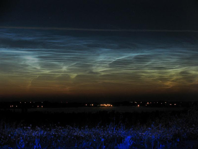

Noctilucent clouds appear to be luminous yet they reflect the sunlight from the other side of the earth at night, giving them a glowing appearance.


Scientists theorize that these “night shining” clouds are formed by ice at the boundary of Earth’s atmosphere and space, 50 miles high. They shine because they are so high they remain lit by the sun even after it has gone below the horizon. It’s not clear why these clouds have migrated down from the poles, or why more of them are appearing in the polar regions, too, and shining more brightly. Nobody knows for sure, but most of the answers seem to point to human-caused global atmospheric change.
The clouds form at temperatures around minus-230 degrees Fahrenheit, when dust blowing up from below or falling into the atmosphere from space provides surfaces for water vapour to condense on and freeze. Right now, during the northern hemisphere’s summer, the atmosphere is heating up and expanding. At the outside edge of the atmosphere, that actually means that it’s getting colder because it’s pushed farther out into space.
The prevailing theory and most plausible explanation is that CO2 build-up, at 50 miles above the surface, would cause the temperature decrease although temperature observations remain inconclusive. There is an ongoing NASA satellite mission to study the clouds. But the truth could be far more complex, and there are many other theories about these clouds.
5. Mushroom Clouds
A mushroom cloud is a distinctive mushroom-shaped cloud of smoke, condensed water vapour, or debris resulting from a very large explosion. They are most commonly associated with nuclear explosions, but any sufficiently large blast will produce the same sort of effect.

Volcano eruptions and impact events can produce natural mushroom clouds.
Mushroom clouds form as a result of the sudden formation of a large mass of hot low-density gases near the ground creating a Rayleigh-Taylor instability. The mass of gas rises rapidly, resulting in turbulent vortices curling downward around its edges and drawing up a column of additional smoke and debris in the centre to form its “stem”. The mass of gas eventually reaches an altitude where it is no longer less dense than the surrounding air and disperses, the debris drawn upward from the ground scattering and drifting back down.


6. Cirrus Kelvin-Helmholtz
Appearing as a slender, horizontal spiral of cloud, cirrus Kelvin-Helmholtz (or Kelvin-Helmholz waves) is one of the most distinctive cloud formations. However, it tends to dissipate only a minute or two after forming and, as a result, is rarely observed. Average height is around 16,500 ft.

These crazy clouds look like a row of crashing waves. They form when two layers of air or liquid of different densities move past each other at different speeds, creating shearing at the boundary.

When these two layers move past each other, a Kelvin-Helmholz instability is formed that is sort of like a wave. Parts of the boundary move up and parts move down. Because one layer is moving faster than the other, the shear causes the tops of the waves to move horizontally, forming what looks like an ocean wave crashing on the beach.
7. Lenticular Clouds
Lenticular Clouds, technically known as altocumulus standing lenticularis, are stationary lens-shaped clouds that form at high altitudes, normally aligned at right-angles to the wind direction.

Where stable moist air flows over a mountain or a range of mountains, a series of large-scale standing waves may form on the downwind side. Lenticular clouds sometimes form at the crests of these waves. Under certain conditions, long strings of lenticular clouds can form, creating a formation known as a wave cloud.


These clouds can often be mistaken for, or sometimes likened to, UFOs! But lenticular clouds are usually created by gravity waves which are like loose shock absorbers. If you drive an old car over a speed bump, it goes up and down for a while. The reason you are going down is because of gravity, and then there are springs in the suspension that push you back up.
In the case of lenticular clouds, the speed bump is usually some kind of topography, like a mountain, that gets in the way of air flow. As the air comes down the side of the mountain, it tends to overshoot and then springs back up. It oscillates like this for a while, and on the upward part of the waves, clouds form as rising air cools. Clouds mark the highest part of the oscillation.
Lenticular clouds can also be caused by other speed bumps, such as tall thunderclouds, but because they often form on the downwind sides of mountains, they are also known as lee clouds, wave clouds or lee wave clouds.
A mountain range can form a series of long wave clouds, but if the speed bump is more isolated, like a single mountain, the result can be oval-shaped clouds that look like UFOs. Sometimes multiple ovals form that look like a stack of saucers.
Check out this video:
Here is another very spooky cloud caught on video:
8. Roll Clouds
A roll cloud is a low, horizontal tube-shaped arcus cloud associated with a thunderstorm gust front, or sometimes a cold front. Roll clouds can also be a sign of possible microburst activity.

Cool air sinking air from a storm cloud’s downdraft spreads out across the surface with the leading edge called a gust front. This outflow undercuts warm air being drawn into the storm’s updraft. As the cool air lifts the warm moist air water condenses creating cloud, which often rolls with the different winds above and below (wind shear).


Here is a video of a Roll Cloud in action:
A specific and more unusual type of roll clouds is the Morning Glory clouds (pictured below).

The Morning Glory phenomenon is the result of the particular configuration of the land and sea on the Cape York Peninsula, in a remote part of Australia. The peninsula tapers off from about 350 miles wide to 60 miles as it extends north between the Gulf of Carpentaria to the west and the Coral Sea to the east. The easterly trade winds push the sea breeze across the peninsula during the daytime, which meets the sea breeze from the west coast in the late evening. The collision produces a wave disturbance moving inland to the southwest that is a key part of the cloud formation. As moist sea air is lifted to the crest of the waves, it cools and condensation forms a cloud. Sometimes there is just one wave, but as many as 10 together in a series have been observed.
These clouds do occur elsewhere, including Munich, where they form about once in a decade. Cape York is unique because they happen regularly in the fall above the small town of Burketown. And they can also be particularly impressive there as well, growing up to 600 miles long. Pilots fly into the area every year, hoping to see the intriguing clouds.
9. Shelf Clouds
A shelf cloud is a low, horizontal wedge-shaped arcus cloud, associated with a thunderstorm gust front (or occasionally with a cold front, even in the absence of thunderstorms).

Unlike a roll cloud, a shelf cloud is attached to the base of the parent cloud above it (usually a thunderstorm).


Rising cloud motion often can be seen in the leading (outer) part of the shelf cloud, while the underside often appears turbulent, boiling, and wind-torn.
10. Stratocumulus Clouds
According to the Sapporo Meteorological Observatory, these low-altitude stratocumulus clouds were rolled into long, distinctive ribbons after becoming trapped in air currents.

While it is not uncommon for wind to form such patterns in stratocumulus clouds, photos that clearly show the clouds rolled into strips are rare, says the observatory.
Sources:
Very nice article! Especially the collection of the pictures is marvelous.
ReplyDeleteFacebooked!!
These items may not constantly make a picture, but whilst blanketed they may almost always make the scene greater ... Eight. Water Towers. Even higher while you tint them and upload some colorful frames. Stunning Pictures of 8 Common Objects
ReplyDelete